This page assembles all current trail closures and detours in the Miami Valley Trail system, due to scheduled trail repair or roadway construction. Where possible, beginning and end dates for the detours and closures are provided.
This information does not include intermittent issues that impact trails such as downed trees or high water. See below for some high water resources.
All DETOURS have CLOSURES, but not all CLOSURES have DETOURS.
A detour is an alternative route selected to safely get around a scheduled trail closure. Detours are commonly routed along surface streets, and involve sharing the road with motor traffic. A trail closure is a section of trail that is closed for use by the trail managing agency due to trail maintenance or roadway construction.
Click titles for more details.
O'Bannon Creek bridge replacement to close trail - Little Miami Scenic Trail
Trail Closed under SR 73 in Corwin - Little Miami Scenic Trail
Trail Closed in downtown Dayton on ONE side of river - Great Miami River Trail
Closure in West Carrollton - Great Miami River Trail
Updated: March 26, 2024
High water, particularly along the Great Miami River Trail, can occasionally inundate the trail making it impassible. We can offer these outside links to help you plan and navigate these potential issues:
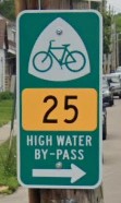 The City of Troy has designated (and signed) a High Water By-Pass route through their beautiful historic downtown for use when high water inundates sections of the Great Miami River Trail which are inside the flood levees. Follow the signs like the one shown here. You can also download and print a route map from here.
The Ohio to Erie Trail Association publishes a page of trail alerts for the 326-mile route from Cincinnati to Cleveland. Click here for alerts along the Ohio to Erie Trail outside of the Miami Valley Trails counties.